Basic Statistics and Location Information
 Lake Marcel is located above the eastern slope of the Snoqualmie River Valley in the Puget lowlands at an elevation of 290 feet above sea level (msl), in the area designated by Washington State as WRIA-7 (Water Resource Inventory Area), which drains to Puget Sound via the Snohomish River. It is about 4,000 feet north of the local unincorporated area called Stillwater and about 9,000 feet west of Lake Joy.
The lake is mapped in the Carnation unit of the USGS 1:24000 topographic series, which was last updated in 1993. Its township-range location is T26NR07E, in section number 33. The midpoint of the lake is located at latitude N 47º41’ 44.1012” and longitude -122º 55’ 4.5658”. The Thomas Guide to King County streets map number is 539.
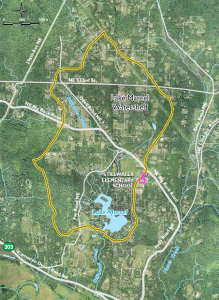
The main roads running through the watershed are the Big Rock Road, which originates from State Highway 203 south of Duvall and runs NW to SE to the Kelly Road, remaining north of Lake Marcel, while the Fay Road, which originates from the Big Rock Road, runs south to Highway 203, remaining west of Lake Marcel (Figure 1).
The lake is 33 acres in surface area, with a reported maximum depth of 17 feet. The watershed draining to the lake is approximately 1290 acres, with six identifiable inlet streams flowing into the lake; the largest one, Stillwater Creek, originates about 1.5 miles to the north (Figure 1).
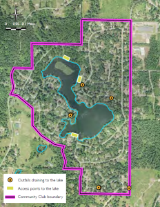
Its entry into Lake Marcel is a concrete-lined channel built in 1963, with fish-ladder steps incorporated. In addition to the inlet streams and direct runoff from properties, there are six outfalls draining to the lake that deliver collected rainwater and surface water runoff (Figure 2).
The outlet is dammed, and a controlled spillway maintains lake level at a fairly constant elevation throughout the year, unlike natural lakes in the region that have high water levels in winter followed by dwindling levels through the summer into mid-fall. The outflow from Lake Marcel is also named Stillwater Creek, which joins Harris Creek at the bottom of the valley slope, shortly before entering the Snoqualmie River system.
The community club maintains three access points to the lake available for residents via community-owned beach properties (Figure 2) for member use, but which are not open for use by the general public. Small boats belonging to owners with no lake
frontage can be kept at two of these properties. Lake Marcel has a no internal combustion engines policy for boats.
Most of the watershed is zoned RA-5, which means one dwelling is allowed per 5 acres of land. This area is characterized by rural land uses, including hobby farms. The land inside the boundaries of the Lake Marcel Community Club and just to the north is currently zoned RA-2.5 to allow for increased density. Because smaller parcels that are currently undeveloped were generally considered as buildable at the time of plating, they are grandfathered and can be permitted for building.

